|
1
|
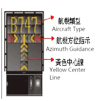
停機位編號指示牌,滑行引導線,目視停靠導引系統
Use of aircraft stand ID signs, TWY guide lines and visual docking/parking guidance system of aircraft stands |
Taxiing guidance signs at all intersections with TWY and at all holding positions. RWY holding position, TWY holding position, Center line, and side stripe, marked and lighted.
Guide lines at aprons. Nose-in guidance at aircraft stands. |
|
2
|
跑道、滑行道標線及燈光
RWY and TWY markings and LGT |
RWY: Designation, THR, TDZ, center line, RWY distance remaining sign, side stripe, edge and runway end as appropriate, marked and lighted.
TWY: RWY holding position, TWY holding position, Center line, and side stripe, marked and lighted. |
|
3
|
停止線燈
Stop bars |
NIL
|
|
4
|
備註
Remarks |
NIL
|
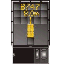
設置於4-11號停機位。
|
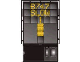
1. 系統介紹
Description of System |
|
|
|
|
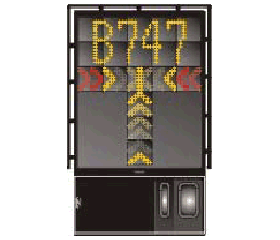
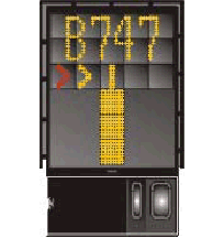
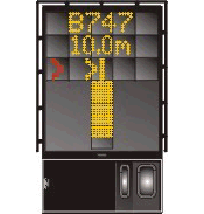
2. 系統自動導引程序
Docking Procedures |
|
|
|
|
|
|
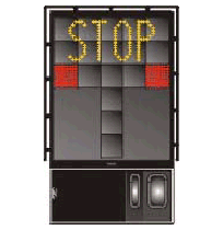
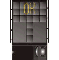
3. 安全警示訊息
Fault Messages and Safety Procedures |
|
|
|


|
起降航道區障礙物
In approach/TKOF areas |
備註
Remarks |
||
|---|---|---|---|
|
跑道名稱/影響區域
RWY NR/Area affected |
障礙物種類、標高、標示/障礙燈
Obstacle type, Elevation, Markings/LGT |
經緯度
Coordinates |
|
| a | b | c | |
| 10APCH/28TKOF | Building 29FT | 250409.90N 1213218.00E | |
| Lightning rod 205FT | 250415.13N 1213034.62E | ||
| Lightning rod 267FT | 250402.42N 1213015.33E | ||
| Lightning rod 293FT | 250401.02N 1213011.05E | ||
| Tree 57FT | 250415.71N 1213215.49E | ||
| Tree 67FT | 250410.00N 1213212.75E | ||
| Tree 62FT | 250415.92N 1213203.82E | ||
| Tree 74FT | 250414.94N 1213157.05E | ||
| Lightning rod 95FT | 250417.38N 1213144.56E | ||
| Tree 157FT | 250423.80N 1213117.50E | ||
| Lightning rod 164FT | 250422.75N 1213107.31E | ||
| Lightning rod 175FT | 250410.93N 1213050.83E | ||
| 28APCH/10TKOF | Camera 35FT | 250406.09N 1213404.96E | |
| Transmission tower 316FT | 250355.76N 1213607.78E | ||
| Transmission tower 344FT | 250357.42N 1213622.40E | ||
| Lightning rod 470FT | 250428.19N 1213814.46E | ||
| Building 624FT | 250343.95N 1213856.33E | ||
| Tree 42FT | 250410.72N 1213407.19E | ||
| Bridge 58FT | 250403.23N 1213419.87E | ||
| Spotlight 94FT | 250409.90N 1213429.89E | ||
| Lightning rod 103FT | 250402.25N 1213433.12E | ||
| Lightning rod 104FT | 250404.01N 1213440.10E | ||
| Lightning rod 135FT | 250403.25N 1213447.92E | ||
| Lightning rod 207FT | 250412.73N 1213533.23E | ||
| Lightning rod 240FT | 250413.65N 1213552.14E | ||
註解: B型機場障礙物圖及相關障礙物資訊請洽本局飛航管制組索取。
電話:02-23496118
電子郵件:ais@mail.caa.gov.tw
電話:02-23496118
電子郵件:ais@mail.caa.gov.tw
|
1
|
相關氣象單位
Associated MET Office |
松山航空氣象臺
Songshan Aeronautical Weather Station |
|
2
|
作業時間
作業時間外負責之氣象單位 Hours of service MET Office outside hours |
H24
|
|
3
|
機場氣象預報負責單位
有效時間 Office responsible for TAF preparation Period of validity |
臺北航空氣象中心
Taipei Aeronautical Meteorological Center 24HR |
|
4
|
趨勢預報
發布間隔 Trend forecast Interval of issuance |
TREND
2-hour validity/half hourly (during 16:00-22:00UTC, interval of issuance is hourly) |
|
5
|
簡報/諮詢方式
Briefing/consultation provided |
Self briefing, Personal briefing and consultation, Telephone
|
|
6
|
飛航文件之資料型態使用語言
Flight documentation Language(s) used |
TAF, METAR, SPECI, Charts
Chinese, English |
|
7
|
供簡報或諮詢之氣象圖或其他資訊
Charts and other information available for briefing or consultation |
Surface Wx Chart, Upper Level Wx Chart, SigWx Prog Chart, Upper Level Wx Prog Chart
|
|
8
|
輔助裝備
Supplementary equipment available for providing information |
LLWAS(including wind speed/direction sensor(12)), AWOS(including wind measuring system(2), RVR(2), Ceilometer(2), Thermograph(2), Pressure sensor(2) and Precipitation detection(2)), Lighted Wind direction indicator, JMDS(JAVA-based Multi-dimensional Display System), Doppler weather radar display system.
|
|
9
|
收受氣象資料之飛航服務單位
ATS units provided with information |
松山機場管制臺, 臺北近場管制塔臺, 臺北飛航諮詢臺
Songshan TWR, Taipei APP, Taipei FIS |
|
10
|
其他資訊 (服務限制等)
Additional information (limitation of service, etc.) |
NIL
|
|
跑道名稱
Designations RWY |
真方位
TRUE BRG |
跑道範圍
Dimension of RWY (M) |
跑道與緩衝區之強度與鋪面
Strength (PCN) and surface of RWY and SWY |
跑道頭經緯度
跑道末端經緯度 大地基準面起伏 THR COORD RWY end COORD THR GUND |
跑道頭標高及精確進場跑道之著陸區最高點標高
THR ELEV and highest ELEV of TDZ of precision APCH RWY |
|---|---|---|---|---|---|
|
1
|
2
|
3
|
4
|
5
|
6
|
|
10
|
092.22
|
2605 x 60
|
RWY: PCN 85/F/C/X/T
CONC+ASPH SWY: NIL |
250412.18N
1213222.64E 250408.89N 1213355.53E GUND: 67 FT |
THR: 13 FT
TDZ: 13 FT |
|
28
|
272.24
|
2605 x 60
|
RWY: PCN 85/F/C/X/T
CONC+ASPH SWY: NIL |
250408.89N
1213355.53E 250412.18N 1213222.64E GUND: 67 FT |
THR: 14 FT
TDZ: 17 FT |
|
跑道名稱
Designations RWY |
攔阻系統位置/說明
Location/ description of arresting system |
障礙物淨空區
OFZ |
備註
Remarks |
|---|---|---|---|
|
1
|
12
|
13
|
14
|
|
10
|
THR 2716 M
EMAS 122.2 M x 69.1 M |
Available
|
跑道地帶寬度不符 Annex 14 之規定。
The width of strip does not meet criteria in Annex 14. |
|
28
|
NIL
|
NIL
|
跑道地帶寬度及 RESA 長度不符 Annex 14 之規定。
The width of strip and the length of RESA does not meet criteria in Annex 14. |
|
跑道名稱
RWY Designator |
進場燈型式、長度、強度
APCH LGT type LEN INTST |
跑道頭燈顏色、有無翼排燈
THR LGT colour WBAR |
目視進場滑降指示燈 (最低眼高) PAPI
VASIS (MEHT) PAPI |
著陸區燈長度
TDZ, LGT LEN |
跑道中心線燈總長度、間距、顏色、強度
RWY Centre Line LGT Length, spacing, colour, INTST |
跑道邊燈總長度、間距、顏色、強度
RWY edge LGT LEN, spacing colour INTST |
跑道末端燈顏色、有無翼排燈
RWY End LGT colour WBAR |
緩衝區燈長度、顏色
SWY LGT LEN (M) colour |
|---|---|---|---|---|---|---|---|---|
|
1
|
2
|
3
|
4
|
5
|
6
|
7
|
8
|
9
|
|
10
|
SSALR
720 M LIH |
Green
WBAR |
PAPI
LEFT/3° (65.15 FT) |
NIL
|
2605M, 30M,
White, White/Red, Red LIH |
2605M, 60M,
White,Yellow, LIH |
Red
No WBAR |
51M
Red Uni-dir |
|
28
|
RTIL
White Uni-dir. |
Green
WBAR |
PAPI
LEFT/3° (64.5 FT) |
NIL
|
2605M, 30M,
White, White/Red, Red LIH |
2605M, 60M,
White, Yellow, LIH |
Red
No WBAR |
NIL
|
|
1
|
機場標燈 /識別標燈之位置,特性及開放時間
ABN/IBN location, characteristics and hours of operation |
|
|
2
|
降落方向指示器位置及燈光風向風速計位置及燈光
LDI location and LGT Anemometer location and LGT |
LDI: NIL
Anemometer: On each runway end. LGTD. |
|
3
|
滑行道邊燈與中心線燈
TWY edge and centre line lighting |
TWY edge light: Blue
TWY centerline lights: TWY E, E1, EH, WH, W, N1 and CC RWY guard lights |
|
4
|
備用電源 /切換時間
Secondary power supply/switch-over time |
Within 1 sec: REDL, RENL, RTHL
Within 15 sec: Other LGT |
|
5
|
備註
Remarks |
NIL
|
|
1
|
起降區中心或最後進離場區跑道頭之經緯度大地基準面起伏
Coordinates TLOF or THR of FATO Geoid undulation |
250405.02N 1213247.58E
|
|
2
|
起降區及最後進離場區之標高
TLOF and/or FATO elevation M/FT |
12 FT
|
|
3
|
起降區及最後進離場區之範圍、鋪面、強度、標線
TLOF and FATO area dimensions, surface, strength, marking |
650PSI
|
|
4
|
進場及起飛區之真方位
True BRG of FATO |
NIL
|
|
5
|
公布距離
Declared distance available |
24M
|
|
6
|
進場及最後進離場區之燈光
APP and FATO lighting |
Perimeter lights
|
|
7
|
備註
Remarks |
夜用風向指示器、滑行道邊燈。
Lighted wind direction indicator, TWY edge light. |
| 1 | 空域名稱及水平範圍
Designation and lateral limits |
臺北/松山機場
TAIPEI/SONGSHAN AERODROME |
| 2 | 空域上下限
Vertical limits |
2500FT MSL |
| 3 | 空域類別
Airspace classification |
Aerodrome traffic circuit. Located in Songshan Class C Airspace. |
| 4 | 航管單位呼號 使用語言
ATS unit call sign Language(s) |
SONGSHAN TWR
Chinese, English |
| 5 | 轉換飛行高度
Transition altitude |
11000FT |
| 6 | 備註
Remarks |
|
|
任務
Service designation |
呼號
Call sign |
頻率
Frequency |
作業時間
Hours of operation |
備註
Remarks |
|---|---|---|---|---|
|
1
|
2
|
3
|
4
|
5
|
|
ATIS
|
SONGSHAN AIRPORT
|
127.40 MHZ
|
2100-1600 (UTC)
|
Data-link D-ATIS AVBL
|
|
341.00 MHZ
|
Data-link D-ATIS AVBL
|
|||
|
EMERG
|
As appropriate
|
121.50 MHZ
|
H24
|
Emergency
|
|
243.00 MHZ
|
Emergency
|
|||
|
TWR
|
SONGSHAN GROUND
|
121.20 MHZ
|
2100-1600 (UTC)
|
許可頒發;地面管制備用頻率
Clearance delivery; ground control alternate frequency |
|
121.90 MHZ
|
地面管制
Ground control |
|||
|
SONGSHAN TOWER
|
118.10 MHZ
|
機場管制
Tower control |
||
|
126.30 MHZ
|
直昇機專用;機場管制備用頻率
Helicopter; tower control alternate frequency |
|||
|
236.60 MHZ
|
機場管制
Tower control |
|||
|
275.80 MHZ
|
機場管制
Tower control |
|
設施類別、磁差、ILS/MLS類別
(VOR/ILS/MLS 磁偏角) Type of aid MAG VAR CAT of ILS/MLS (for VOR/ILS/MLS, give declination) |
識別
ID |
頻率
Frequency |
作業時間
Hours of operation |
電臺發射天線位置
Site of transmitting antenna coordinates |
DME 天線標高
Elevation of DME transmitting antenna |
備 註
Remarks |
|---|---|---|---|---|---|---|
|
1
|
2
|
3
|
4
|
5
|
6
|
7
|
|
LOC 10
ILS CAT I |
ITSG
|
108.90 MHZ
|
H24
|
250408.6N
1213404.2E |
|
前航道區角:4.2°,
因受地形影響,航道中心線左右20°以外,7NM 以外及在17NM以外,4500FT 以下,不能使用。(建議駕駛員飛至TAZAN定位點再攔截ILS信號進場)。 Front course sector angle: 4.2°, Due to terrain, beyond 20° left/right of course centerline, beyond 7NM, and beyond 17NM, below 4500FT unusable. (Pilots are advised to fly to TAZAN DME fix first and thence establish on RWY 10 ILS) |
|
GP 10
ILS CAT I |
|
329.30 MHZ
|
H24
|
250415.5N
1213235.5E |
|
滑降角3°,
RDH 55FT。 因受機場外建物、路樹等障礙物影響,訊號超過航道中心線左側5.5°以外不能使用,及訊號位於ITSG 1.5D至0.6D間訊號不穩定,但均符合飛測容差。 Angle 3˚, RDH 55FT. Due to obstacles, the signals beyond 5.5° left of center line course are unusable and the signals between ITSG 1.5D and 0.6D are unstable, but within the flight checking tolerance. |
|
DME 10
ILS CAT I |
ITSG
|
(CH26X)
|
H24
|
250415.3N
1213235.8E |
25 FT
|
與10跑道儀器降落系統滑降臺同址。
因受地形影響,航道中心線左右20°以外,7NM 以外不可使用。 Co-located with RWY 10 ILS GP. Due to terrain, beyond 20° left/right of course centerline, beyond 7NM unusable. |
|
LDA 28
|
ITLU
|
108.10 MHZ
|
H24
|
250405.0N
1213356.5E |
|
LDA偏架7°
LDA course offset from RWY center line by 7°. |
|
DME 28
|
ITLU
|
(CH18X)
|
H24
|
250403.5N
1213354.7E |
45 FT
|
|
|
NDB
(04° W) |
AP
|
250.00 KHZ
|
H24
|
251032.5N
1213120.5E |
|
|
|
VOR/DME
(04° W) |
APU
|
112.50 MHZ
(CH72X) |
H24
|
251036.7N
1213120.1E |
3594 FT
|
VOR因受地形影響,幅向115-315之間區域,儀表指示可能有暫時擺動之現象。
VOR Signals in the area where the radial 115-315 are affected by terrain. Thus, the VOR navigation indicator may swing temporarily. |
|
NDB
(04° W) |
HL
|
362.00 KHZ
|
H24
|
243349.0N
1204349.4E |
|
|
|
VOR/DME
(04° W) |
HLG
|
114.00 MHZ
(CH87X) |
H24
|
243335.3N
1204337.8E |
575 FT
|
|
|
L
|
LU
|
357.00 KHZ
|
H24
|
250822.1N
1214803.3E |
|
|
|
VOR/DME
(04° W) |
MKG
|
115.20 MHZ
(CH99X) |
H24
|
233543.6N
1193814.2E |
77 FT
|
|
|
VOR/DME
(04° W) |
TSI
|
113.50 MHZ
(CH82X) |
H24
|
250403.0N
1213354.7E |
54 FT
|
VOR受地形影響,輻向020-060及輻向100-360等區間15NM以外訊號不能使用。
DME受地形影響,輻向340-026及039高度7000FT以下14NM以外訊號不能使用。 Due to terrain, VOR radials 020-060 and 100-360 are unusable when the range beyond 15NM. Due to terrain, DME range beyond 14 NM below 7000FT is unusable at radials between 340-026 and 039. |
-
航空器地面操作限制
- 航空器在停機坪(含連接停機坪之滑行道)因滑行錯誤, 或已滑過指定之停機位置, 禁止在原地做"U"形轉彎, 此時駕駛員應停車(或慢車)並告知塔臺須利用拖車, 拖至所須之方向或指定之停放位置。
- 航空器在停機坪須靠已起動之引擎使用大油門輔助其他引擎啟動時, 禁止在停機坪實施。 如作業上確切需要, 經航空站航務組許可後轉告塔臺,通知駕駛員可將航空器利用拖車拖至滑行道上並平行後始可實施。在作業時, 地面工作人員仍須隨時注意, 以免危害後面其他航空器之活動。
- 離場航空器禁止自中央滑行道進入跑道後實施短場起飛。
- 交叉口起飛:螺旋槳民用航空器得請求或管制員得指示其自E1、EH、WH滑行道進入跑道交叉口起飛。
- 航空器後推時, 因受機坪面積限制, 為使航空器易於活動,可將航空器推至約45度方向, 以利其朝向起飛跑道方向滑行。
- Engineering Material Arresting System (EMAS)可提供航速70KT之下之AIRBUS A333型航機安全煞停,惟使用後之EMAS應由航空器所屬公司依「松山機場故障航空器移離作業程序規定」儘速復原並負擔全部復原費用。
- 因跑滑道配置關係,有2個地點常有航空器錯過塔臺所指示之滑行道而誤入軍方機坪,請航空器注意,茲列出HOT SPOT如下:
-
本場飛行限制
- 宵禁時間:每日1500至2200世界標準時間民用航空器禁止起降, 緊急情況除外。
-
跑道定期關閉:每日0155-0215 (UTC)
跑道定期關閉時段可能取消,並以NOTAM 通知。 - 當風速10KT以下時,得不使用與風向一致之跑道,航空器不能遵守此規定時,應告知航管單位。
- 10跑道右航線。
- 除起降時遭遇緊急情況外, 航空器禁止進入10跑道緩衝區。
- 飛越限航區RCR16之規定:詳見ENR 5.1。
- 松山機場因地形障礙及建築物障礙為特殊機場, 飛航松山機場必須遵守AIP內各離場之爬升梯度規定, 以確保飛航安全。
- 固定翼航空器不得實施目視進場、特種目視飛航及機場航線。
- 機場之天氣情況低於目視飛航天氣最低標準;而雲幕高900FT以上,且地面能見度1500M以上時,於松山C類空域得申請特種目視飛航,並經飛航管制單位准許後實施。
- 儀器飛航程序起飛天氣限度

駕駛員在松山機場附近飛航時,需確按各機種降低噪音操作程序操作,避開RCR48限航區並儘量縮短飛越市區之時間。
|
等待點
Holding Fix |
經緯度
Coordinates |
等待點
Holding Fix |
經緯度
Coordinates |
|---|---|---|---|
| BESOM | 250524.07N 1215128.45E | LU L | 250822.10N 1214803.30E |
| DUPAR | 251353.83N 1215158.21E | PINSI | 250232.20N 1215017.77E |
| FUSIN | 245157.38N 1212703.01E | PUTIN | 244708.46N 1205949.23E |
| JONHO | 245540.77N 1211819.94E | YILAN | 244422.60N 1214730.48E |
| KUDOS | 250753.00N 1215928.00E | ZONLI | 245709.38N 1211207.82E |
註解: 其他資訊參照ENR 1.5.6及相關航圖。
由臺北/松山機場離場之航班,一律頒發5000FT空層(有相關航情時不在此限),起飛後再由臺北近場管制塔臺及臺北區域管制中心頒發適當空層。
|
鳥種
Bird Type |
活動季節與時間 Activity Time |
活動區域
Activity Area |
飛行高度
Flight Height |
特性
Characteristics |
|---|---|---|---|---|
|
麻雀、大卷尾、家八哥、白尾八哥
Eurasian Tree Sparrow, Black Drongo, Common Myna, Javan Myna |
全年
Whole year |
跑道及滑行道兩側草坪
Grass beside RWY and TWYs |
GND-60FT | 體重約21至155g,小型及中型鳥種。
Around 21-155g weight, small to medium sized species. |
|
紅鳩、斑頸鳩
Red Turtle Dove, Spotted Dove |
全年
Whole year |
跑道及滑行道兩側草坪
Grass beside RWY and TWYs |
GND-60FT | 體重約106至154g,中型鳥種。
Around 106-154g weight, medium sized species. |
|
小白鷺
Little Egret |
全年
Whole year |
跑道及滑行道兩側草坪
Grass beside RWY and TWYs |
GND-60FT | 體重約322g,中型鳥種。下雨後草坪積水,常出現覓食。
About 322g weight, medium sized species. Usually forage around the ponds of the lawns after the rain. |
|
喜鵲
Eurasian Magpie |
全年
Whole year |
跑道及滑行道兩側草坪
Grass beside RWY and TWYs |
GND-60FT | 體重約192g,中型鳥種。
Around 192g weight, medium sized species. |
|
鴿子
Pigeon |
全年
Whole year |
跑道、滑行道、28跑道頭東南方約700M處
RWY, TWYs, 700 M from south-east of THR 28 |
60-150FT | 體重約315g,中型鳥種。
Around 315g weight, medium sized species. |
|
黃頭鷺
Cattle Egret |
全年,3月至10月份出現數量較多
Whole year, mainly appear from MAR to OCT |
由機場北面基隆河飛進跑道兩側草坪
Fly from Keelung River (north of airport) to grass beside RWY |
GND-120FT | 體重約370g,中型鳥種。割草作業會吸引黃頭鷺大量聚集覓食。
Around 370g weight, medium sized species. Mowing activities attract flocks forage together. |
|
紅隼
Eurasian Kestrel |
每年9月至翌年4月份
From SEP to next APR |
跑道及滑行道兩側草坪
Grass beside RWY and TWYs |
GND-120FT | 體重約198g,中型鳥種。
Around 198g weight, medium sized species. |
|
小環頸鴴
Little Ringed Plover |
每年8月至12月份
From AUG to DEC |
跑道及滑行道兩側草坪
Grass beside RWY and TWYs |
GND-60FT | 體重約35g,小型鳥種。
Around 35g weight, small sized species. |
|
白頭翁
Light-vented Bulbul |
每年4月至9月份
From APR to SEP |
跑道及滑行道兩側草坪
Grass beside RWY and TWYs |
GND-60FT | 體重約38g,小型鳥種。
Around 38g weight, small sized species. |
|
家燕
Barn Swallow |
全年,3月至9月份出現數量較多。
Whole year, mainly appear from MAR to SEP |
跑道及滑行道兩側草坪
Grass beside RWY and TWYs |
GND-60FT | 體重約15g,小型鳥種。
Around 15g weight, small sized species. |
|
黃鶺鴒
Yellow Wagtail |
每年9月至12月份
From SEP to DEC |
跑道及滑行道兩側草坪
Grass beside RWY and TWYs |
GND-60FT | 體重約21g,小型鳥種。
Around 21g weight, small sized species. |
|
鸕鶿
Great Cormorant |
每年10月至翌年4月份,0500-1600,活動高峰0500-0600及1430-1600。
From OCT to APR, 0500-1600, highly active at 0500-0600 and 1430-1600 |
基隆河水域、機場上空
Keelung River or above the airport |
GND-1650FT | 體重約1810~2810g,大型鳥種。
Around 1810-2810g weight, large sized species. |
註解: 上表所列之時間係本地時間 (UTC+8),另鳥類飛行高度,係觀察鳥類活動所目測之概估值。
|
編號
NR |
障礙物類型
Obstacle Type |
坐標
COORD |
標高
ELEV (FT) |
穿越量
Penetration (FT) |
儀器進場程序
IAP |
|---|---|---|---|---|---|
| 1 | 2 | 3 | 4 | 5 | 6 |
| 1 | Lightning rod | 250405.10N 1213202.35E | 105 | 37 | VOR RWY10 |
| 2 | Tree | 250410.00N 1213212.77E | 67 | 30 | |
| 3 | Building | 250404.98N 1213206.12E | 75 | 19 | |
| 4 | Building | 250404.97N 1213205.57E | 75 | 17 | |
| 5 | Building | 250405.00N 1213205.09E | 76 | 16 | |
| 6 | Lightning rod | 250400.55N 1213142.27E | 144 | 16 | |
| 7 | Lightning rod | 250400.56N 1213141.52E | 144 | 14 | |
| 8 | Lightning rod | 250357.57N 1213125.47E | 192 | 14 | |
| 9 | Building | 250404.64N 1213204.06E | 75 | 12 | |
| 10 | Lightning rod | 250400.55N 1213138.42E | 151 | 12 | |
| 11 | Lightning rod | 250405.02N 1213157.49E | 94 | 11 | |
| 12 | Building | 250404.58N 1213203.57E | 75 | 11 | |
| 13 | Building | 250405.04N 1213203.08E | 76 | 11 | |
| 14 | Lightning rod | 250404.26N 1213203.07E | 75 | 10 | |
| 15 | Building | 250404.94N 1213204.53E | 69 | 8 | |
| 16 | Tree | 250410.00N 1213212.77E | 67 | 30 | RNP RWY10 |
| 17 | Tree | 250420.88N 1213502.03E | 304 | 53 |
LDA RWY28 VOR RWY28 |
| 18 | Lightning rod | 250421.70N 1213500.42E | 291 | 45 | |
| 19 | Tree | 250421.75N 1213458.19E | 274 | 36 | |
| 20 | Tree | 250421.71N 1213456.96E | 268 | 35 | |
| 21 | Tree | 250420.00N 1213501.00E | 283 | 35 | |
| 22 | Tree | 250420.08N 1213501.36E | 284 | 34 | |
| 23 | Tree | 250420.37N 1213500.26E | 280 | 34 | |
| 24 | Antenna tower | 250421.71N 1213500.09E | 278 | 33 | |
| 25 | Tree | 250419.97N 1213500.40E | 279 | 33 | |
| 26 | Tree | 250420.56N 1213502.75E | 287 | 33 | |
| 27 | Tree | 250420.46N 1213500.66E | 279 | 32 | |
| 28 | Terrain | 250423.12N 1213458.76E | 270 | 30 | |
| 29 | Tree | 250419.96N 1213502.15E | 282 | 30 | |
| 30 | Building | 250421.55N 1213500.98E | 276 | 29 | |
| 31 | Building | 250421.65N 1213500.94E | 275 | 28 | |
| 32 | Tree | 250418.92N 1213500.79E | 272 | 25 | |
| 33 | Terrain | 250421.82N 1213500.18E | 266 | 22 | |
| 34 | Tree | 250420.34N 1213502.76E | 274 | 19 | |
| 35 | Terrain | 250423.12N 1213500.90E | 266 | 19 | |
| 36 | Terrain | 250420.52N 1213500.88E | 266 | 19 | |
| 37 | Tree | 250419.97N 1213503.45E | 275 | 18 | |
| 38 | Tree | 250420.16N 1213457.01E | 250 | 17 | |
| 39 | Lightning rod | 250420.27N 1213431.19E | 150 | 13 | |
| 40 | Tree | 250419.85N 1213457.32E | 244 | 9 | |
| 41 | Terrain | 250430.82N 1213536.29E | 387 | 9 | |
| 42 | Sign board | 250415.07N 1213411.62E | 73 | 8 | |
| 43 | Tree | 250418.04N 1213506.27E | 271 | 3 | |
| 44 | Terrain | 250423.75N 1213504.47E | 263 | 3 | |
| 45 | Tree | 250420.88N 1213502.03E | 304 | 46 | RNP RWY28 |
| 46 | Lightning rod | 250421.70N 1213500.42E | 291 | 39 | |
| 47 | Tree | 250421.75N 1213458.19E | 274 | 30 | |
| 48 | Tree | 250421.71N 1213456.96E | 268 | 29 | |
| 49 | Terrain | 250422.07N 1213500.13E | 279 | 29 | |
| 50 | Tree | 250420.00N 1213501.00E | 283 | 29 | |
| 51 | Tree | 250420.37N 1213500.26E | 280 | 28 | |
| 52 | Tree | 250420.08N 1213501.36E | 284 | 28 | |
| 53 | Antenna tower | 250421.71N 1213500.09E | 278 | 27 | |
| 54 | Tree | 250419.97N 1213500.40E | 279 | 27 | |
| 55 | Tree | 250420.56N 1213502.75E | 287 | 26 | |
| 56 | Tree | 250420.46N 1213500.66E | 279 | 26 | |
| 57 | Tree | 250419.96N 1213502.15E | 282 | 24 | |
| 58 | Building | 250421.55N 1213500.98E | 276 | 23 | |
| 59 | Terrain | 250421.42N 1213500.14E | 273 | 22 | |
| 60 | Building | 250421.65N 1213500.94E | 275 | 22 | |
| 61 | Terrain | 250422.74N 1213501.55E | 276 | 20 | |
| 62 | Tree | 250418.92N 1213500.79E | 272 | 19 | |
| 63 | Terrain | 250420.79N 1213501.57E | 270 | 13 | |
| 64 | Tree | 250420.34N 1213502.76E | 274 | 13 | |
| 65 | Tree | 250419.97N 1213503.45E | 275 | 11 | |
| 66 | Tree | 250420.16N 1213457.01E | 250 | 11 | |
| 67 | Sign board | 250415.07N 1213411.62E | 73 | 6 | |
| 68 | Tree | 250419.85N 1213457.32E | 244 | 3 |