|
|
|
|
民用 陸地
Civil Land
|
|
軍用 陸地
Military Land
|
|
軍民合用 陸地
Joint civil and military Land
|
|
直昇機機場
Heliport
Note.─Aerodrome for the exclusive use of helicopters
|
|
以跑道圖示替代機場符號
Note.─Where required by the function of the chart, the runway pattern of the aerodrome may be show in lieu of the aerodrome symbol, for example:
|
|
|
|
|
|
|
硬式道面跑道
Hard surface runway
|
|
無鋪砌面跑道
Unpaved runway
|
|
緩衝區(SWY)
Stopway (SWY)
|
|
滑行道及停機坪
Taxiways and parking areas
|
|
機場內之直昇機降落區
Helicopter alighting area on an aerodrome
|
|
機場參考點
Aerodrome reference point ARP
|
|
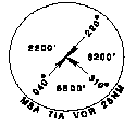
VOR 校準點
VOR check-point
|
|
跑道視程 (RVR) 觀測點
Runway visual range(RVR) observation site
|
|
點狀燈
Point light
|
|
障礙燈
Obstacle light
|
|
有燈光之降落方向指示器
Landing direction indicator(lighted)
|
|
無燈光之降落方向指示器
Landing direction indicator(unlighted)
|
|
停止線燈
Stop bar
|
|
跑道等待位置 A型
Runway-holding position Pattern A
|
|
跑道等待位置 B型
Runway-holding position Pattern B
|
|
|
2.3.3 AERODROME OBSTACLE CHARTS-TYPE A, B AND C
|
|
|
|
|
平面
Plan
|
剖面
Profile
|
樹或灌木
Tree or shrub
|
|
識別數字
Identification number
|
桿、塔、錐狀物、天線
Pole, tower, spire, antenna, etc.
|
|
大型建築物
Building or large structure
|
|
鐵路
Railroad
|
|
輸電線或架空纜線
Transmission line or overhead cable
|
|
穿越障礙物面之地形
Terrain penetrating obstacle plane
|
|
|
懸崖
Escarpment
|
|
緩衝區(SWY)
Stopway (SWY)
|
|
清除區(CWY)
Clearway (CWY)
|
|
|
2.3.4 RADIO NAVIGATION AIDS
|
|
|
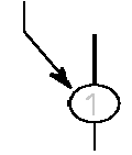
基本無線電助導航設施
Basic radio navigation aid symbol
Note.─This symbol may be used with or without a box to enclose the data.
|
|
歸航台(NDB)
Non-directional radio beacon (NDB)
|
|
特高頻多向導航台(VOR)
VHF omnidirectional radio range (VOR)
|
|
|
測距儀(DME)
Distance measuring equipment (DME)
|
|
同址之VOR與DME (VOR/DME)
Collocated VOR and DME (VOR/DME)
radio navigation aids
|
|
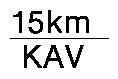
DME距離
DME distance
|
距DME之距離
Distance in kilometres(nautical miles)to DME
|
|
電台識別
Identification of radio navigation aid
|
VOR輻向
VOR radial
|
|
輻向、電台識別
Radial bearing from, and identification of VOR
|
極高頻戰術航空導航設施(TACAN)
UHF tactical air navigation aid (TACAN)
|
|
VOR與TACAN同址之無線電助導航設施(VORTAC)
Collocated VOR and TACAN (VORTAC) radio navigation aids
|
|
儀器降落系統(ILS)
Instrument landing (ILS) system
|
PLAN VIEW
|
|
PROFILE
|
Electronic
|
無線電信標台
Radio marker beacon
|
橢圓形
Elliptical
|
|
骨型
Bone Shape
|
|
註:可用輪廓或網點或兩者一併來表示
Note.─Marker beacon may be shown by outline, or stipple, or both
|
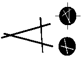
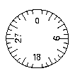
羅盤刻度
Compass
To be orientaated on the chart in accordance with the alignment of the station(normally Magnetic North)
|
|
羅盤刻度與右列符號語言使用:
Compass rose to be used as appropriate in combination with the following symbols:
|
VOR |
|
|
VOR/DME
|
|
|
TACAN
|
|
|
VORTAC
|
|
|
2.3.5 AIR TRAFFIC SERVICE
|
|
|
飛航情報區(FIR)
Flight information region FIR
|
|
管制區域(CTA)
航路 (AWY)
Control area (CTA)
Airway Controlled route (AWY)
|
|
管制地帶(CTR)
Control Zone (CTR)
|
|
防空識別區(ADIZ)
Air defence identification Zone (ADIZ)
|
|
比例尺中斷
(在飛航服務航線上)
Scale-break
(on ATS route)
|
任擇其一
Alternative
|
|
|
|
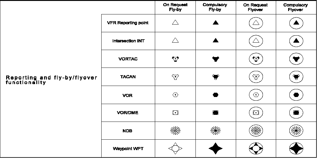
飛航服務/氣象 報告點(MRP)
ATS/MET reporting point (MRP)
|
強制
Compulsory
|
|
非強制
On request
|
|
|
|
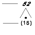
最後進場定位點 (FAF)
Final approach fix (FAF)
|
|
高度/飛航空層
Altitudes/flight levels
|
高度/飛航空層區間
Altitude/flight level "window"
|
|
|
某高度/飛航空層或以上
"At or above" altitude/ flight level
|
|
|
某高度/飛航空層或以下
"At or below" altitude/ flight level
|
|
|
規定高度/飛航空層
"Mandatory" altitude/ flight level
|
|
|
建議程序高度/飛航空層
"Recommended" procedure altitude/ flight level
|
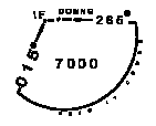
7000 |
FL130 |
預計高度/飛航空層
"Expected" altitude
|
Expect 7000 |
Expect FL130 |
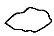
限航空域(禁航區、限航區或危險區)
Restricted airspace
(prohibited, restricted or danger area)
|
|
|
Note.─The angle and density of rulings may be varied according to scale and the size, shape and orientation of the area
|
|
|
|
|
|
障礙物
Obstacle
|
|
有燈光之障礙物
Lighted obstacle
|
|
障礙物群
Group obstacles
|
|
有燈光之障礙物群
Lighted group obstacles
|
|
頂部標高(斜體字)
Elevation of to top (italics)
|
|
某基準面以上之標高
(以括弧包圍之正體字)
Height above specified datum
(upright type in parentheses)
|
顯著之輸電纜線
Prominent transmission line
|
|
等磁差線
Isogonic line or isogonal
|
|
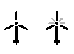
風力發電機
Wind turbine - unlighted and lighted
|
|
風力發電機﹝區域﹞
Wind turbines - minor group and group in major area, lighted
|
|
航空地面燈
Aeronautical ground light
|
|
|
區域最低高度
Area minimum altitude
|
|
|
平面圖
PLAN VIEW
|
最低區域高度
Minimum sector altitude (MSA)
Note. ─This symbol may be modified to reflect particular sector shapes.
|
|
終端到場高度
Terminal arrival altitude
Note. ─ This symbol may be modified to reflect particular TAA shapes TAA
|
|
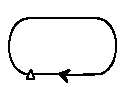
等待航線
Holding pattern
|
|
誤失進場航跡
Missed approach track
|
|
剖面圖
PROFILE
|
跑道
Runway
|
|
無線電助導航設施
Radio navigation aid
(type of aid and its use in the procedure to be annotated on top of the symbol)
|
|
無線電信標台
Radio marker beacon (type of beacon to be annotated on top of the symbol)
|
|
同址之無線電助導航設施及信標台
Collocated radio navigation aid and marker beacon
(type of aid to be annotated on top of the symbol)
|
|
DME fix
(distance from DME and the fix use in the procedure to be annotated on top of the symbol)
|
|
同址之DME fix及信標台
Collocated DME fix and marker beacon (distance from DME and the type of beacon to be annotated on top of the symbol)
|
|
|