|
1
|
停機位編號指示牌,滑行引導線,目視停靠導引系統
Use of aircraft stand ID signs, TWY guide lines and visual docking/parking guidance system of aircraft stands |
Aircraft stand identification signs, guide lines at apron, taxiing guidance signs at all intersections of TWY/RWY and at all holding positions.
|
|
2
|
跑道、滑行道標線及燈光
RWY and TWY markings and LGT |
RWY: Designation, THR, TDZ, RWY distance remaining sign and center line, edge and RWY end as appropriate, marked and lighted.
TWY: Holding positions at all TWY/RWY intersections, marked and lighted; center lines. |
|
3
|
停止線燈
Stop bars |
NIL
|
|
4
|
備註
Remarks |
NIL
|
設置於12-37號停機位。
|
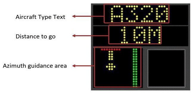
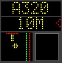
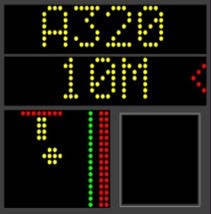
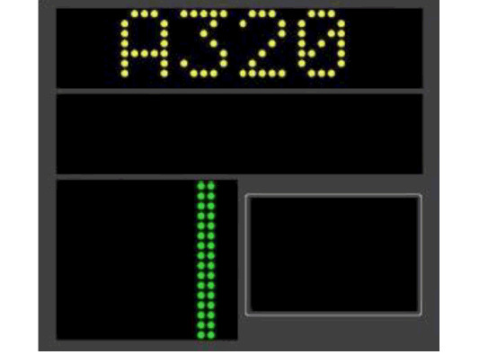
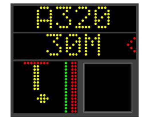
RLG GIS206-2
系統簡介 Description of System |
|
|
|
|
|
|
航機位於綠色方位中心線。
ACFT on the green azimuth center bar. |
||
|
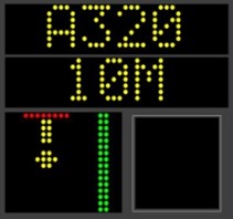
航機偏離綠色方位中心線左方,應向綠色方位中心線移動。
ACFT a little left of the green azimuth center bar, steer towards the green azimuth center bar. |
||
|
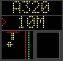
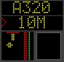
航機更偏離綠色方位中心線左方,應向綠色方位中心線移動。
ACFT more left of the green azimuth center bar, steer towards the green azimuth center bar. |
||
|
航機偏離綠色方位中心線右方,應向綠色方位中心線移動。
ACFT a little right of the green azimuth center bar, steer towards the green azimuth center bar. |
||
|
航機更偏離綠色方位中心線右方,應向綠色方位中心線移動。
ACFT more right of the green azimuth center bar, steer towards the green azimuth center bar. |
||
|
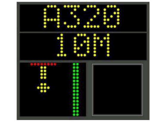
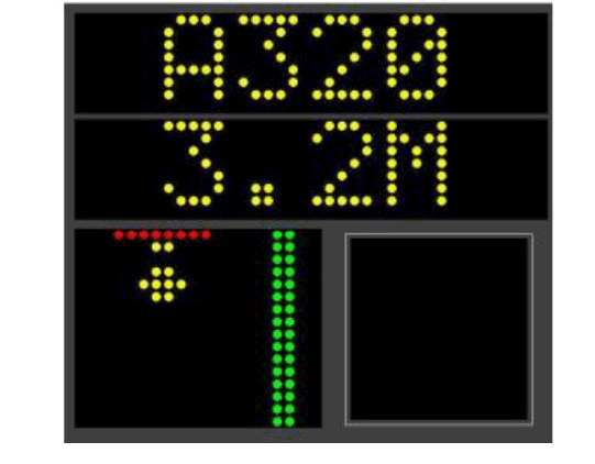
當航機經系統識別為航機後,黃色位置箭頭將出現。黃色位置箭頭會隨航機之靠近而逐漸縮短,表示航機正朝停止線靠近中。當航機距離停止線0.2M範圍內時,系統會顯示STOP且黃色位置箭頭將變為直線形狀(與停止線形成T字形狀),表示航機已到達停止線。當系統確認航機未再滑行,第二列接著顯示OK。
When the aircraft is captured by the system and confirmed to be an aircraft, a yellow location arrow will appear. The yellow location arrow will gradually shorten as the aircraft approaches, indicating that the aircraft is approaching the stop line, When the aircraft is within 0.2M of the stop line, the word "STOP" will be displayed and the yellow location arrow will be changed into a straight line shape (forming a T shape with the stop line), indicating that the stop line has been reached. If no motion is detected, the word "OK" will be displayed to follow. |
||
|
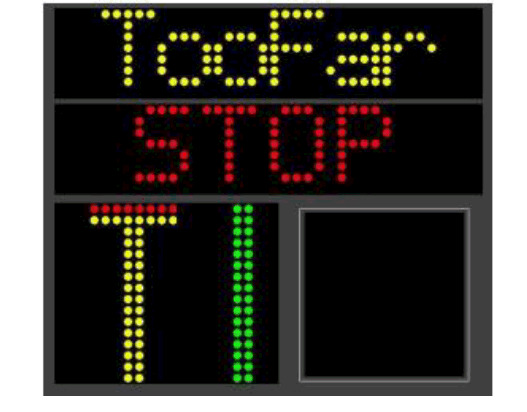
若駕駛員未及時剎車,導致航機鼻輪超越停止線,第一列顯示 TooFar,此時航機應立即剎車。
If the aircraft has overshoot the stop position, the word "TooFar" is displayed. The aircraft shall stop immediately. |
||
|
第一列交互顯示ID/FAIL、第二列同時顯示STOP,表示系統偵測航機機型錯誤,航機應立即剎車,由引導員人工導引。
The system displays alternate "ID/FAIL" in the first row. The second row displaying "STOP" indicates that the incoming aircraft is identified and verified incorrectly. The aircraft shall stop immediately and must be manually guided in by a marshaller. |
||
|
第一、第二列同時顯示STOP,航機應立即剎車,由引導員人工導引。
The first and second row will display "STOP". The aircraft shall stop immediately and must be manually guided in by a marshaller. |
||
|
第一、第二列分別顯示ERROR/STOP,表示系統發生故障,航機應立即剎車,由引導員人工導引。
The first and second row displaying "ERROR" and "STOP" indicates the system detects any hardware error. The aircraft shall stop immediately and must be manually guided in by a marshaller. |
||


|
起降航道區障礙物
In approach/TKOF areas |
備註
Remarks |
||
|---|---|---|---|
|
跑道名稱/影響區域
RWY NR/Area affected |
障礙物種類、標高、標示/障礙燈
Obstacle type, Elevation, Markings/LGT |
經緯度
Coordinates |
|
| a | b | c | |
| 27APCH/09TKOF | Building 43FT | 223434.91N 1202206.42E | |
| Building 45FT | 223437.36N 1202206.89E | ||
| Water Tower 136FT | 223438.98N 1202224.63E | ||
| Lightning rod 96FT | 223438.76N 1202217.87E | ||
| Tree 247FT | 223432.29N 1202341.32E | ||
| Tree 239FT | 223420.36N 1202330.20E | ||
| Tree 197FT | 223429.04N 1202248.78E | ||
| Tree 179FT | 223438.75N 1202240.15E | ||
| 09APCH/27TKOF | Water Tower 38FT | 223443.27N 1201954.57E | |
| Tree 40FT | 223440.99N 1201950.48E | ||
| Building 84FT | 223437.83N 1201926.50E | ||
| Lightning rod 118FT | 223441.33N 1201917.80E | ||
| Lightning rod 146FT | 223444.89N 1201858.24E | ||
| Lightning rod 158FT | 223440.20N 1201856.78E | ||
| Lightning rod 83FT | 223443.55N 1201930.24E | ||
| Antenna 76FT | 223444.04N 1201936.37E | ||
| Iron Tower 131FT | 223435.89N 1201902.04E | ||
註解: B型機場障礙物圖及相關障礙物資訊請洽本局飛航管制組索取。
電話:02-23496118
電子郵件:ais@mail.caa.gov.tw
電話:02-23496118
電子郵件:ais@mail.caa.gov.tw
|
1
|
相關氣象單位
Associated MET Office |
高雄航空氣象臺
Kaohsiung Aeronautical Weather Station |
|
2
|
作業時間
作業時間外負責之氣象單位 Hours of service MET Office outside hours |
H24
|
|
3
|
機場氣象預報負責單位
有效時間 Office responsible for TAF preparation Period of validity |
臺北航空氣象中心
Taipei Aeronautical Meteorological Center 30HR |
|
4
|
趨勢預報
發布間隔 Trend forecast Interval of issuance |
TREND
2-hour validity / half hourly (during 1600-2200UTC, interval of issuance is hourly) |
|
5
|
簡報/諮詢方式
Briefing/consultation provided |
Self briefing, Personal briefing and consultation, Telephone
|
|
6
|
飛航文件之資料型態使用語言
Flight documentation Language(s) used |
機場預報、機場例行天氣報告、機場特別天氣報告、氣象圖
TAF, METAR, SPECI, Charts Chinese, English |
|
7
|
供簡報或諮詢之氣象圖或其他資訊
Charts and other information available for briefing or consultation |
Surface Wx Chart, Upper Level Wx Chart, SigWx Prog Chart, Upper Wind and Temperature Chart.
|
|
8
|
輔助裝備
Supplementary equipment available for providing information |
AWOS(including wind speed/direction sensor(3), RVR(2), Ceilometer(2), Thermograph(2), Pressure sensor(2) and Precipitation detection(2)), Anemometer(2), Wind cone(2), JMDS(JAVA-based Multi-dimensional Display System), RWES(Radar Weather Extracting System).
|
|
9
|
收受氣象資料之飛航服務單位
ATS units provided with information |
高雄塔臺, 高雄近場臺, 高雄飛航諮詢臺
Kaohsiung TWR, Kaohsiung APP, Kaohsiung FIS |
|
10
|
其他資訊 (服務限制等)
Additional information (limitation of service, etc.) |
因無適當儀器測量垂直風切及斜向能見度,故此等資料暫不測報。
Pending the availability of suitable equipment, vertical wind shear slant and visual range observations are not made. |
|
跑道名稱
Designations RWY |
真方位
TRUE BRG |
跑道範圍
Dimension of RWY (M) |
跑道與緩衝區之強度與鋪面
Strength and surface of RWY and SWY |
跑道頭經緯度
跑道末端經緯度 大地基準面起伏 THR COORD RWY end COORD THR GUND |
跑道頭標高及精確進場跑道之著陸區最高點標高
THR ELEV and highest ELEV of TDZ of precision APCH RWY |
|---|---|---|---|---|---|
|
1
|
2
|
3
|
4
|
5
|
6
|
|
09
|
091.90
|
3150 x 60
|
RWY: PCR 1180/R/A/W/T
CONC+ASPH SWY: ASPH |
223438.97N
1202011.10E 223435.74N 1202155.76E GUND: NIL |
THR: 21 FT
TDZ: 25 FT |
|
27
|
271.93
|
3150 x 60
|
RWY: PCR 1180/R/A/W/T
CONC+ASPH SWY: NIL |
223436.22N
1202140.18E 223439.14N 1202005.55E GUND: NIL |
THR: 31 FT
TDZ: 31 FT |
|
跑道名稱
RWY Designator |
進場燈型式、長度、強度
APCH LGT type LEN INTST |
跑道頭燈顏色、有無翼排燈
THR LGT colour WBAR |
目視進場滑降指示燈 (最低眼高) PAPI
VASIS (MEHT) PAPI |
著陸區燈長度
TDZ, LGT LEN |
跑道中心線燈總長度、間距、顏色、強度
RWY Centre Line LGT Length, spacing, colour, INTST |
跑道邊燈總長度、間距、顏色、強度
RWY edge LGT LEN, spacing colour INTST |
跑道末端燈顏色、有無翼排燈
RWY End LGT colour WBAR |
緩衝區燈長度、顏色
SWY LGT LEN (M) colour |
|---|---|---|---|---|---|---|---|---|
|
1
|
2
|
3
|
4
|
5
|
6
|
7
|
8
|
9
|
|
09
|
MALSR
720 M LIM |
Green
WBAR |
PAPI
LEFT/3° (59.9 FT) |
White, 900M
|
3150M, 15M,
White, White/Red, Red, LIH |
3150M,60M,
Red, White, Yellow, LIH. |
Red
No WBAR |
60M
Red |
|
27
|
CAT1
720M LIH |
Green
WBAR |
PAPI
RIGHT/3° (62.3 FT) |
NIL
|
3150M, 15M,
White, White/Red, Red, LIH |
3150M,60M,
Red, White, Yellow, LIH |
Red
No WBAR |
NIL
|
|
1
|
機場標燈 /識別標燈之位置,特性及開放時間
ABN/IBN location, characteristics and hours of operation |
|
|
2
|
降落方向指示器位置及燈光風向風速計位置及燈光
LDI location and LGT Anemometer location and LGT |
LDI: NIL
Anemometer: One at both thresholds and the other at the central part of runway, 90M from runway center line. |
|
3
|
滑行道邊燈與中心線燈
TWY edge and centre line lighting |
Blue (No edge light on the north side of TWY A)
TWY A and TWY G with centerline light. Runway guard lights. |
|
4
|
備用電源 /切換時間
Secondary power supply/switch-over time |
Within 1 sec: REDL, RENL, RCLL, RTZL
Within 15 sec: Other LGT |
|
5
|
備註
Remarks |
NIL
|
|
1
|
起降區中心或最後進離場區跑道頭之經緯度大地基準面起伏
Coordinates TLOF or THR of FATO Geoid undulation |
NIL
|
|
2
|
起降區及最後進離場區之標高
TLOF and/or FATO elevation M/FT |
NIL
|
|
3
|
起降區及最後進離場區之範圍、鋪面、強度、標線
TLOF and FATO area dimensions, surface, strength, marking |
NIL
|
|
4
|
進場及起飛區之真方位
True BRG of FATO |
NIL
|
|
5
|
公布距離
Declared distance available |
NIL
|
|
6
|
進場及最後進離場區之燈光
APP and FATO lighting |
NIL
|
|
7
|
備註
Remarks |
NIL
|
| 1 | 空域名稱及水平範圍
Designation and lateral limits |
高雄國際機場
KAOHSIUNG INTERNATIONAL AERODROME |
| 2 | 空域上下限
Vertical limits |
2500FT MSL |
| 3 | 空域類別
Airspace classification |
Aerodrome traffic circuit. Located in the Kaohsiung Class D Airspace. |
| 4 | 航管單位呼號 使用語言
ATS unit call sign Language(s) |
KAOHSIUNG TWR
Chinese, English |
| 5 | 轉換飛行高度
Transition altitude |
11000FT |
| 6 | 備註
Remarks |
|
|
任務
Service designation |
呼號
Call sign |
頻率
Frequency |
作業時間
Hours of operation |
備註
Remarks |
|---|---|---|---|---|
|
1
|
2
|
3
|
4
|
5
|
|
APP
|
KAOHSIUNG APPROACH
|
121.10 MHZ
|
H24
|
NIL
|
|
124.70 MHZ
|
NIL
|
|||
|
125.70 MHZ
|
備用頻率
alternate frequency |
|||
|
228.40 MHZ
|
NIL
|
|||
|
232.20 MHZ
|
備用頻率
alternate frequency |
|||
|
324.80 MHZ
|
NIL
|
|||
|
328.70 MHZ
|
備用頻率
alternate frequency |
|||
|
KAOHSIUNG FLIGHT FOLLOW
|
119.50 MHZ
|
目視飛航通訊追蹤席
VFR Flight following |
||
|
135.80 MHZ
|
目視飛航通訊追蹤席
VFR Flight following |
|||
|
329.50 MHZ
|
目視飛航通訊追蹤席
VFR Flight following |
|||
|
ATIS
|
KAOHSIUNG INTL AIRPORT
|
127.80 MHZ
|
2200-1600 (UTC)
|
Data-link D-ATIS AVBL.
|
|
EMERG
|
As appropriate
|
121.50 MHZ
|
H24
|
Emergency
|
|
243.00 MHZ
|
Emergency
|
|||
|
TWR
|
KAOHSIUNG TOWER
|
118.70 MHZ
|
2200-1600 (UTC)
|
NIL
|
|
120.70 MHZ
|
備用頻率
alternate frequency |
|||
|
236.60 MHZ
|
NIL
|
|||
|
KAOHSIUNG GROUND
|
121.80 MHZ
|
備用頻率
alternate frequency |
||
|
121.90 MHZ
|
NIL
|
|
設施類別、磁差、ILS/MLS類別
(VOR/ILS/MLS 磁偏角) Type of aid MAG VAR CAT of ILS/MLS (for VOR/ILS/MLS, give declination) |
識別
ID |
頻率
Frequency |
作業時間
Hours of operation |
電臺發射天線位置
Site of transmitting antenna coordinates |
DME 天線標高
Elevation of DME transmitting antenna |
備 註
Remarks |
|---|---|---|---|---|---|---|
|
1
|
2
|
3
|
4
|
5
|
6
|
7
|
|
LOC 09
ILS CAT I |
IKHG
|
108.30 MHZ
|
H24
|
223435.4N
1202206.2E |
|
前航道區角:3.7°
因受地形影響,航道中心線左側26°以外,7NM以外,2000FT以下,不可使用。 Front course sector angle: 3.7° Due to terrain, beyond 26° left of course centerline, beyond 7NM, below 2000FT unusable. |
|
GP 09
ILS CAT I |
|
334.10 MHZ
|
H24
|
223441.8N
1202022.6E |
|
滑降角3°
Angle 3˚, RDH 53FT |
|
DME 09
ILS CAT I |
IKHG
|
(CH20X)
|
H24
|
223441.7N
1202022.6E |
33 FT
|
與09跑道儀器降落系統滑降臺同址。
因受地形影響,航道中心線左側26°以外,7NM以外,2000FT以下,不可使用。 Co-located with RWY 09 ILS GP. Due to terrain, beyond 26° left of course centerline, beyond 7NM, below 2000FT unusable. |
|
LOC 27
ILS CAT I |
IKAS
|
109.70 MHZ
|
H24
|
223439.4N
1201957.4E |
|
前航道區角:4.17°
Front course sector angle: 4.17° |
|
GP 27
ILS CAT I |
|
333.20 MHZ
|
H24
|
223441.2N
1202128.6E |
|
滑降角 3°
Angle 3˚, RDH 57FT |
|
DME 27
ILS CAT I |
IKAS
|
(CH34X)
|
H24
|
223441.1N
1202128.6E |
43 FT
|
與27跑道儀器降落系統滑降臺同址。
Co-located with RWY 27 ILS GP. |
|
VOR/DME
(04° W) |
HCN
|
113.70 MHZ
(CH84X) |
H24
|
215540.0N
1205036.9E |
403 FT
|
VOR因地形關係,輻向322-342於40NM外、6000FT以下不能使用。
Due to terrain, VOR radial 322-342 beyond 40NM, below 6000FT unusable. |
|
L
|
SK
|
330.00 KHZ
|
H24
|
223440.1N
1201934.9E |
|
|
-
航空器地面操作限制
- 航空器在停機坪(含連接停機坪之滑行道)因滑行錯誤,或已滑過指定之停機位,除經過機場管理單位允許外,禁止在原地180度迴轉,此時駕駛員應停車(或慢車)並告知塔臺須利用拖車,拖至所須之方向或指定之停放位置。
- 民用航空器(直昇機除外)在停機坪內,不得自行迴轉滑出停機坪至滑行道/滑行路徑。
- 航機滑行轉彎時應判斷採取過度轉向,以確保外側主輪軌跡與鋪面邊緣達到國際民航組織所建議之淨距。
- 由於機尾噴流可能影響相鄰機坪或棚廠,航空器於17號停機位後推時,機頭僅能朝西;12號停機位後推時機頭僅能朝東。
- A350-900、A350-1000、B787-10及B777-300ER在A或B滑行道可用時避開G滑行道,以免損害其鋪面。
- Boeing B747-800型機停機及滑行程序
- 因滑行道配置關係,有5個地點具潛在碰撞風險,請航空器注意,茲列出熱點(HOT SPOT)如下:
- 航空器引擎交叉開車作業程序
註解: 其他資訊參照ENR 1.5.6及相關航圖。
西子灣、衛武營、萬大橋、鳳山水庫、鳳鼻頭、雙園大橋。
|
鳥種
Bird Type |
活動季節與時間
Activity Time |
活動區域
Activity Area |
飛行高度
Flight Height |
特性
Characteristics |
|---|---|---|---|---|
|
麻雀
Eurasian Tree Sparrow |
全年
Whole year |
跑道、滑行道、機場草坪
RWY, TWYs and grass area at the airport |
GND-50FT | 體重約22g,小型鳥種。
Around 22g weight, small sized species. |
|
鴿子
Pigeon |
全年
Whole year |
跑道、滑行道、機場草坪
RWY, TWYs and grass area at the airport |
GND-50FT | 體重約315g,中型鳥種。
Around 315g weight, medium sized species. |
|
紅鳩
Red Turtle Dove |
全年
Whole year |
09/27跑道北側草坪
North grass of RWY 09/27 |
GND-50FT | 體重約106g,中型鳥種。
Around 106g weight, medium sized species. |
|
斑頸鳩
Spotted Dove |
全年
Whole year |
09/27跑道北側草坪
North grass of RWY 09/27 |
GND-50FT | 體重約154g,中型鳥種。
Around 154g weight, medium sized species. |
|
白頭翁
Light-vented Bulbul |
全年
Whole year |
機場草坪
Grass area at the airport |
GND-50FT | 體重約39g,小型鳥種。
Around 39g weight, small sized species. |
|
白尾八哥
Javan Myna |
全年
Whole year |
機場草坪
Grass area at the airport |
GND-50FT | 體重約86g,小型鳥種。
Around 86g weight, small sized species. |
|
家燕
Barn Swallow |
全年
Whole year |
跑道、滑行道、機場草坪
RWY, TWYs and grass area at the airport |
GND-50FT | 體重約15g,小型鳥種。
Around 15g weight, small sized species. |
|
洋燕
Pacific Swallow |
全年
Whole year |
跑道、滑行道、機場草坪
RWY, TWYs and grass area at the airport |
GND-50FT | 體重約16g,小型鳥種。
Around 16g weight, small sized species. |
|
黃頭鷺
Cattle Egret |
全年
Whole year |
機場草坪
Grass area at the airport |
GND-100FT | 體重約368g,中型鳥種。
Around 368g weight, medium sized species |
|
每年8月至10月份,1300至夜間遷飛活動
From AUG to OCT, migration starts from 1300 to nighttime |
27跑道東方約1.5KM處、27跑道東南方約4.6KM處
1.5KM east of RWY 27; 4.6KM south-east of RWY 27 |
GND-1200FT | ||
|
每年2月至4月份
From FEB to APR |
由機場27跑道東南方約4.6KM處(鳳山水庫)離開,沿09跑道西方高雄港外海北上飛行
Fly from Fengshan reservoir (4.6KM south-east of the airport) toward the outer sea of Kaohsiung Port |
50FT-1200FT | ||
|
鸕鶿
Great Cormorant |
每年11月至翌年4月份
From NOV to next APR |
由09跑道西方高雄港外海飛行至機場東南方約4.6公里處(鳳山水庫)
Fly from the outer sea of Kaohsiung Port toward Fengshan reservoir (south-east 4.6KM of the airport) |
180FT-500FT | 體重約2600至3700g,大型鳥種。
Around 2600-3700g weight, large sized species. |
|
每年11月至翌年4月份上午至黃昏
From NOV to next APR, Morning till sunset |
27跑道東南方約4.6公里處(鳳山水庫)至水庫以東2公里處(高屏溪)、09跑道西方高雄港外海
Fly from Fengshan reservoir (4.6KM south-east of the airport), toward Gaoping River (2KM east of Fengshan reservoir) or toward the outer sea of Kaohsiung Port |
|||
|
黑翅鳶
Black-shouldered Kite |
全年,晨間、日間及黃昏
Whole year, in the dusk, daytime and dawn |
跑道、滑行道、跑道北側草坪、機場草坪上空
RWYs, TWYs, north grass area of RWYs and grass area at the airport |
GND-100FT | 體重約180g-220g,中型鳥種。
Around 180g-220g weight, medium sized species. |
|
小白鷺
Little Egret |
每年5月至10月份,日間
From MAY to OCT Daytime |
機場草坪、割草作業處、積水處、機場北側排水溝
Grass area at the airport, grass cutting area, puddles, drains in north side of the airport |
GND-1200FT
|
體重約180g-220g,中型鳥種。
Around 180g-220g weight, medium sized species. |
註解: 上表所列之時間係本地時間 (UTC+8),另鳥類飛行高度,係觀察鳥類活動所目測之概估值。

NIL