|
1
|
停機位編號指示牌,滑行引導線,目視停靠導引系統
Use of aircraft stand ID signs, TWY guide lines and visual docking/parking guidance system of aircraft stands |
Taxiing guidance signs at all intersections with TWY and at all holding positions. Aircraft stand ID signs, Guide lines.
|
|
2
|
跑道、滑行道標線及燈光
RWY and TWY markings and LGT |
RWY: Designation, TDZ, Centerline as appropriate marked. THR, side stripe, edge runway end as appropriate, marked and lighted. RWY distance remaining sign.
TWY: Centerline, all TWY/RWY intersections and TWY/TWY intersections as appropriate marked edge, marked and lighted. |
|
3
|
停止線燈
Stop bars |
NIL
|
|
4
|
備註
Remarks |
NIL
|
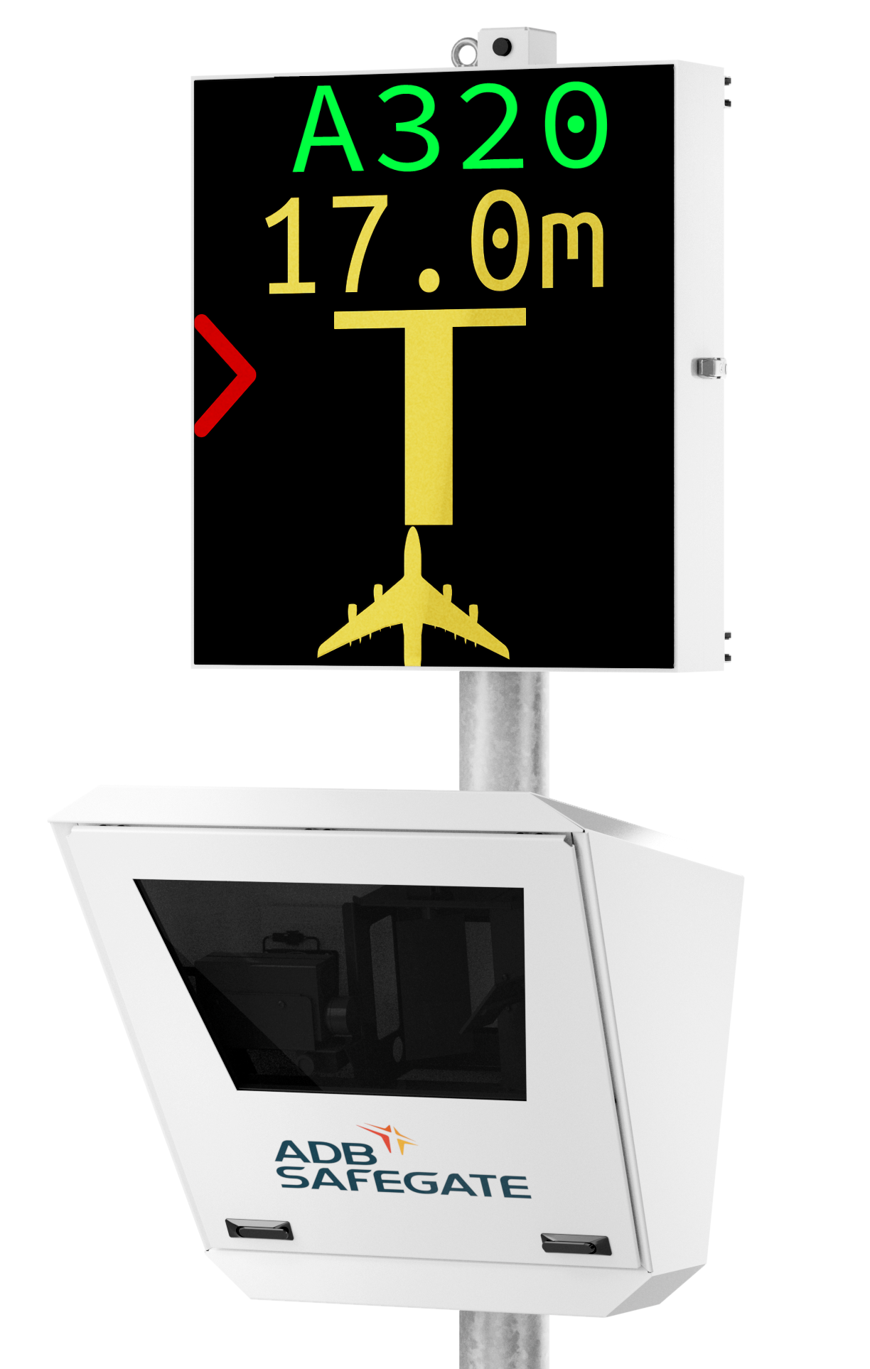
ADB SAFEGATE Safedock FleX
A-VDGS
設置於1-8號停機位。
設置於1-8號停機位。
|
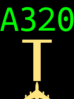
請檢查顯⽰的機型是否正確。滾動箭頭表⽰系統已啟動
。
Check that the correct aircraft type is displayed. The scrolling arrows indicate that the system is activated. |
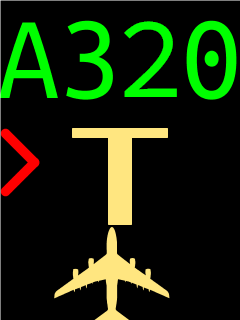
當航機被雷射偵測到時,系統會檢查該航機是否為正確機型。驗證成功後,航機ID將從黃⾊變為綠⾊,顯⽰器會提供⽅位導引資訊。當黃⾊中⼼線出現時,表⽰系統正在追蹤該航機。在箭頭被黃⾊中⼼線取代之前,航機不得前進超越空橋
。
When the aircraft has been caught by the laser, the system checks that the aircraft is the correct type. Upon successful verification, the aircraft ID will change from yellow to green and the display provides azimuth guidance information. When the yellow center line indicator appears, the aircraft is being tracked by the system. The aircraft must not proceed beyond the bridge, unless the arrows have been superseded by the yellow center line indicator. |
||
|
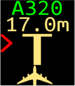
閃爍的紅⾊箭頭表⽰需要調整的⽅向,⽽黃⾊航機圖⽰則表⽰航機偏離中⼼線的程度
。
The flashing red arrow shows which direction to steer, while the yellow aircraft icon indicator gives an indication of how far the aircraft is off the centerline. |
當航機距離停⽌位置30M,黃⾊中⼼線隨著航機前進⽽縮短,數字顯⽰停⽌位置前的距離
。
When the aircraft is 30M from the stop-position, the yellow center line indicator reduced and the digital countdown will indicate the remaining distance toward the stop position. |
||
|
當到達正確的停⽌位置時,以紅框字體顯⽰STOP
。
When the correct stop-position is reached, the STOP sign in red with red border will be displayed. |
若航機停妥於正確位置,稍候顯⽰OK
。
If the aircraft stops at the correct position, OK will be displayed after a few seconds. |
||
|
地⾯⼈員已放置輪檔
。
The aircraft wheel chocks have been set by ground personnel. |
若航機超過停⽌位置,顯⽰TOO FAR
。
If the aircraft has overshot the stop position, TOO FAR will be displayed. |
||
|
航機必須在正確停⽌位置前15M完成識別,否則系統顯⽰WAIT、STOP及ID FAIL
。
The aircraft must be identified at least 15m before the correct stop position. Otherwise, WAIT, STOP and ID FAIL will be displayed. |
|||
|
航機應以最低速滑⾏進入停機位,若航機進入時超過允許速度,或遇濃霧/⼤雨造成系統視程降低,系統顯⽰SLOW
。
Aircraft shall taxi into the stand at minimum speed. If the aircraft is approaching faster than the accepted speed, or the visibility of system is reduced due to heavy fog/rain, SLOW will be displayed. |
任何在停靠程序中無法恢復的錯誤將導致SBU(Safety back-up)狀態。系統停⽤,航機由引導員⼈⼯導引
。
Any unrecoverable error during the docking procedure will generate an SBU (Safety back-up) condition. The system will be suspended, and the aircraft must be manually guided in by marshaller. |
||
|
若系統與進入航機之間視線受阻,例如雷射透鏡或雷射視窗有髒污,或最近之⽬視區有其他障礙物,停靠程序中⽌並顯⽰WAIT與VIEW BLOCK訊息。系統停⽤,航機由引導員⼈⼯導引
。
If the view towards the approaching aircraft is hindered, for example, internally in the unit of the laser lens or on the laser window by dirt, or another obstacle in the closest view area, the docking procedure will be halted with a WAIT and VIEW BLOCK message. The system will be suspended, and the aircraft must be manually guided in by marshaller. |
若發現有物體阻擋系統與航機預定停⽌位置的視線,停靠程序中⽌並顯⽰WAIT與GATE BLOCK訊息。系統停⽤,航機由引導員⼈⼯導引
。
If an object is found blocking the approach to gate view from the system to the planned stop-position for the aircraft, the docking procedure will be halted with a WAIT and GATE BLOCK message. The system will be suspended, and the aircraft must be manually guided in by marshaller. |
||


|
起降航道區障礙物
In approach/TKOF areas |
備註
Remarks |
||
|---|---|---|---|
|
跑道名稱/影響區域
RWY NR/Area affected |
障礙物種類、標高、標示、障礙燈
Obstacle type, Elevation, Markings/LGT |
經緯度
Coordinates |
|
| a | b | c | |
| 18APCH/36TKOF | Tree 685FT | 241709.69N 1203706.34E | |
| Tree 674FT | 241705.64N 1203711.49E | ||
| Tree 671FT | 241658.93N 1203712.09E | ||
| Tree 665FT | 241655.77N 1203712.43E | ||
| Tree 665FT | 241656.19N 1203712.28E | ||
註解: B型機場障礙物圖及相關障礙物資訊請洽本局飛航管制組索取。
電話:02-23496118
電子郵件:ais@mail.caa.gov.tw
電話:02-23496118
電子郵件:ais@mail.caa.gov.tw
|
1
|
相關氣象單位
Associated MET Office |
清泉崗空軍基地
Cingcyuangang Air Base |
|
2
|
作業時間
作業時間外負責之氣象單位 Hours of service MET Office outside hours |
H24
|
|
3
|
機場氣象預報負責單位
有效時間 Office responsible for TAF preparation Period of validity |
天氣中心
WX Center H24 |
|
4
|
趨勢預報
發布間隔 Trend forecast Interval of issuance |
TREND
Hourly |
|
5
|
簡報/諮詢方式
Briefing/consultation provided |
Telephone
|
|
6
|
飛航文件之資料型態使用語言
Flight documentation Language(s) used |
Abbreviated plain language, charts
Chinese |
|
7
|
供簡報或諮詢之氣象圖或其他資訊
Charts and other information available for briefing or consultation |
S12, U85, U7, U5, U3, U2 (Remark: S: Surface analysis chart, U: upper level analysis chart)
|
|
8
|
輔助裝備
Supplementary equipment available for providing information |
AWOS(including wind measuring system(3), Thermograph(2), Pressure sensor(2), Precipitation detection(2), ceilometer(2), RVR(2), lightning detection(1))
|
|
9
|
收受氣象資料之飛航服務單位
ATS units provided with information |
NIL
|
|
10
|
其他資訊 (服務限制等)
Additional information (limitation of service, etc.) |
NIL
|
|
跑道名稱
Designations RWY |
真方位
TRUE BRG |
跑道範圍
Dimension of RWY (M) |
跑道與緩衝區之強度與鋪面
Strength and surface of RWY and SWY |
跑道頭經緯度
跑道末端經緯度 大地基準面起伏 THR COORD RWY end COORD THR GUND |
跑道頭標高及精確進場跑道之著陸區最高點標高
THR ELEV and highest ELEV of TDZ of precision APCH RWY |
|---|---|---|---|---|---|
|
1
|
2
|
3
|
4
|
5
|
6
|
|
18
|
176.69
|
3659 x 61
|
RWY: PCR 410/R/A/W/T
CONC SWY: NIL |
241653.58N
1203710.65E 241454.86N 1203718.52E GUND: 64 FT |
THR: 653 FT
TDZ: 657 FT |
|
36
|
356.69
|
3659 x 61
|
RWY: PCR 410/R/A/W/T
CONC SWY: NIL |
241454.86N
1203718.52E 241653.58N 1203710.65E GUND: 64 FT |
THR: 663 FT
TDZ: 665 FT |
|
跑道名稱
Designations RWY |
攔阻系統位置/說明
Location/ description of arresting system |
障礙物淨空區
OFZ |
備註
Remarks |
|---|---|---|---|
|
1
|
12
|
13
|
14
|
|
18
|
THR 3686 M
61QSII ELEV 678 FT THR 3263 M BAK_14_HOOK |
NIL
|
NIL
|
|
36
|
THR 3684 M
61QSII ELEV 688 FT THR 3278 M BAK_14_HOOK |
NIL
|
跑道端安全區寬度不符 Annex 14 之規定。
The width of RESA does not meet criteria in Annex 14. |
|
跑道名稱
RWY Designator |
進場燈型式、長度、強度
APCH LGT type LEN INTST |
跑道頭燈顏色、有無翼排燈
THR LGT colour WBAR |
目視進場滑降指示燈 (最低眼高) PAPI
VASIS (MEHT) PAPI |
著陸區燈長度
TDZ, LGT LEN |
跑道中心線燈總長度、間距、顏色、強度
RWY Centre Line LGT Length, spacing, colour, INTST |
跑道邊燈總長度、間距、顏色、強度
RWY edge LGT LEN, spacing colour INTST |
跑道末端燈顏色、有無翼排燈
RWY End LGT colour WBAR |
緩衝區燈長度、顏色
SWY LGT LEN (M) colour |
|---|---|---|---|---|---|---|---|---|
|
1
|
2
|
3
|
4
|
5
|
6
|
7
|
8
|
9
|
|
18
|
RAI
300M White, FLG LIH, Uni-dir |
Green
WBAR |
PAPI
LEFT/3° (57.32 FT) |
NIL
|
NIL
|
3659M, 60M,
White, Yellow, LIH |
Red
No WBAR |
NIL
|
|
36
|
ALSF-1
900M LIH |
Green
WBAR |
PAPI
LEFT/3° (56.68 FT) |
NIL
|
NIL
|
3659M, 60M,
White, Yellow, LIH |
Red
No WBAR |
NIL
|
|
1
|
機場標燈 /識別標燈之位置,特性及開放時間
ABN/IBN location, characteristics and hours of operation |
|
|
2
|
降落方向指示器位置及燈光風向風速計位置及燈光
LDI location and LGT Anemometer location and LGT |
LDI: NIL
Anemometer: Two sets of anemometers, one located at 300M from THR RWY 18, 75M from RCL; another located at 300M from THR RWY 36, 75M from RCL |
|
3
|
滑行道邊燈與中心線燈
TWY edge and centre line lighting |
TWY edge lights: Blue
|
|
4
|
備用電源 /切換時間
Secondary power supply/switch-over time |
2 sets of 200KW secondary power supply/13 sec.
|
|
5
|
備註
Remarks |
NIL
|
|
1
|
起降區中心或最後進離場區跑道頭之經緯度大地基準面起伏
Coordinates TLOF or THR of FATO Geoid undulation |
NIL
|
|
2
|
起降區及最後進離場區之標高
TLOF and/or FATO elevation M/FT |
NIL
|
|
3
|
起降區及最後進離場區之範圍、鋪面、強度、標線
TLOF and FATO area dimensions, surface, strength, marking |
NIL
|
|
4
|
進場及起飛區之真方位
True BRG of FATO |
NIL
|
|
5
|
公布距離
Declared distance available |
NIL
|
|
6
|
進場及最後進離場區之燈光
APP and FATO lighting |
NIL
|
|
7
|
備註
Remarks |
直昇機使用W滑行道或跑道起降。
Taxiway W or runway are used for helicopter take off and landing. |
| 1 | 空域名稱及水平範圍
Designation and lateral limits |
臺中/清泉崗機場
TAICHUNG/CINGCYUANGANG AERODROME |
| 2 | 空域上下限
Vertical limits |
3000FT MSL |
| 3 | 空域類別
Airspace classification |
Aerodrome traffic circuit. Located in the Taichng Class D Airspace |
| 4 | 航管單位呼號 使用語言
ATS unit call sign Language(s) |
CCK TOWER
Chinese , English |
| 5 | 轉換飛行高度
Transition altitude |
11000FT |
| 6 | 備註 |
|
|
任務
Service designation |
呼號
Call sign |
頻率
Frequency |
作業時間
Hours of operation |
備註
Remarks |
|---|---|---|---|---|
|
1
|
2
|
3
|
4
|
5
|
|
APP
|
TAIPEI APPROACH
|
121.50 MHZ
|
H24
|
NIL
|
|
129.60 MHZ
|
NIL
|
|||
|
130.10 MHZ
|
NIL
|
|||
|
257.80 MHZ
|
NIL
|
|||
|
301.00 MHZ
|
NIL
|
|||
|
301.50 MHZ
|
NIL
|
|||
|
TAIPEI FLIGHT FOLLOW
|
135.80 MHZ
|
目視飛航通訊追蹤
VFR Flight following |
||
|
318.20 MHZ
|
目視飛航通訊追蹤
VFR Flight following |
|||
|
329.50 MHZ
|
目視飛航通訊追蹤
VFR Flight following |
|||
|
ATIS
|
CINGCYUANGANG AIRPORT
|
127.75 MHZ
|
2300-1500 (UTC)
|
Data-link D-ATIS AVBL
|
|
EMERG
|
As appropriate
|
121.50 MHZ
|
H24
|
Emergency
|
|
243.00 MHZ
|
Emergency
|
|||
|
TWR
|
CCK GROUND
|
120.25 MHZ
|
2300-1500 (UTC)
|
由中華民國空軍管理。
Operated by ROCAF. |
|
CCK TOWER
|
118.75 MHZ
|
由中華民國空軍管理。
Operated by ROCAF. |
|
設施類別、磁差、ILS/MLS類別
(VOR/ILS/MLS 磁偏角) Type of aid MAG VAR CAT of ILS/MLS (for VOR/ILS/MLS, give declination) |
識別
ID |
頻率
Frequency |
作業時間
Hours of operation |
電臺發射天線位置
Site of transmitting antenna coordinates |
DME 天線標高
Elevation of DME transmitting antenna |
備 註
Remarks |
|---|---|---|---|---|---|---|
|
1
|
2
|
3
|
4
|
5
|
6
|
7
|
|
LOC 18
ILS CAT I |
ITCG
|
111.70 MHZ
|
H24
|
241444.8N
1203719.2E |
|
前航道區角:3.1°
Front course sector angle: 3.1˚ |
|
GP 18
ILS CAT I |
|
333.50 MHZ
|
H24
|
241643.5N
1203708.3E |
|
滑降角3°
Angle 3˚, RDH 52.85FT |
|
DME 18
ILS CAT I |
ITCG
|
(CH54X)
|
H24
|
241643.3N
1203708.4E |
728 FT
|
與18跑道儀器降落系統滑降臺同址。
Co-located with RWY 18 ILS GP |
|
LOC 36
ILS CAT I |
ICCK
|
111.50 MHZ
|
H24
|
241703.9N
1203710.0E |
|
前航道區角:3.08°
Front course sector angle: 3.08˚ |
|
GP 36
ILS CAT I |
|
332.90 MHZ
|
H24
|
241505.4N
1203722.1E |
|
滑降角3°
Angle 3˚, RDH 54.13FT |
|
DME 36
ILS CAT I |
ICCK
|
(CH52X)
|
H24
|
241505.8N
1203722.2E |
675 FT
|
與36跑道儀器降落系統滑降臺同址。
Co-located with RWY 36 ILS GP |
|
NDB
|
HL
|
362.00 KHZ
|
H24
|
243349.0N
1204349.4E |
|
|
|
VOR/DME
(04° W) |
HLG
|
114.00 MHZ
(CH87X) |
H24
|
243335.3N
1204337.8E |
575 FT
|
|
|
VOR/DME
(04° W) |
MKG
|
115.20 MHZ
(CH99X) |
H24
|
233543.6N
1193814.2E |
77 FT
|
|
|
L
|
TC
|
210.00 KHZ
|
H24
|
241512.8N
1203707.2E |
|
|
|
DME
|
TCK
|
(CH21X)
|
H24
|
241513.0N
1203707.5E |
679 FT
|
|
NIL
註解: 其他資訊參照ENR 1.5.6及相關航圖。
本場18跑道頭及36跑道頭以外約3500FT範圍內的農地及樹林,全年常見小型及中型鳥類飛行高度約100FT至500FT,機場內鳥類活動資訊如下:
|
鳥種
Bird Type |
活動季節與時間
Activity Time |
活動區域
Activity Area |
飛行高度
Flight Height |
特性
Characteristics |
|---|---|---|---|---|
|
麻雀
Eurasian Tree Sparrow |
全年
Whole year |
跑道兩側草坪
Grass beside RWY |
GND-100FT | 體重約22g,小型鳥種。
Around 22g weight, small sized species. |
|
紅鳩
Red Turtle Dove |
全年
Whole year |
跑道及滑行道兩側、18跑道頭鄰側樹林
Grass beside RWY and TWYs, woods near THR 18 |
GND-150FT | 體重約106g,中型鳥種。
Around 106g weight, medium sized species. |
|
鴿子
Pigeon |
全年
Whole year |
36跑道頭附近、跑道西側農地
Near THR 36, west farmlands of RWY |
GND-300FT | 體重約315g,中型鳥種。
Around 315g weight, medium sized species. |
|
黑翅鳶
Black-winged Kite |
每年4月至11月份在早晨及黃昏時間出現
From APR to NOV, Morning and dusk time |
機場內
At the airport |
100FT-350FT | 體重約106至154g,中型鳥種。
Around 106-154g weight, medium sized species. |
|
小白鷺、黃頭鷺
Little Egret, Cattle Egret |
每年3月至10月份
From MAR to OCT |
跑道及滑行道兩側草坪
Grass beside RWY and TWYs |
GND-300FT | 體重約322至 341g,中型鳥種。
Around 322-341g weight, medium sized species |
|
全年
Whole year |
18跑道西北方約9.7KM處
9.7KM north-west from RWY 18 |
GND-1200FT | ||
|
36跑道南方約1KM處(十三寮滯洪池)、36跑道南方約8.2KM處(國道1號高速公路中港交流道)、36跑道西南方約3.7KM處(大肚山垃圾掩埋場)
1KM south from RWY 36 (Shisanliao detention pond); 8.2KM south from RWY 36 (Zhonggang System Interchange, National Highway No. 1); 3.7KM south-west from RWY 36 (Dadushan landfill site) |
||||
|
燕鴴
Oriental Pratincole |
每年4至10月份
From APR to OCT |
跑道及滑行道
RWY and TWYs |
GND-50FT | 體重約80g,小型鳥種。
Around 80g weight, small sized species. |
|
臺灣夜鷹
Savanna Nightjar |
每年5月至10月份夜間
From MAY to OCT, Night time |
跑道及滑行道
RWY and TWYs |
GND-100FT | 體重約80g,小型鳥種。
Around 80g weight, small sized species. |
|
雨燕、家燕
House Swift, Barn Swallow |
每年4月至10月份
From APR to OCT |
跑道及滑行道
RWY and TWYs |
GND-50FT | 體重約16至21g,小型鳥種。
Around 16-21g weight, small sized species. |
|
環頸雉
Ring-necked Pheasant |
全年
Whole year |
跑道及滑行道
RWY and TWYs |
GND-70FT | 體重約1100g,大型鳥種。
Around 1100g weight, large sized species. |
|
灰面鵟鷹
Butastur indicus |
每年3至4月份
From MAR to APR |
由36跑道南方約20KM處(八卦山)向北飛行
Fly north from 20KM south of RWY 36 (Baguashan) |
300FT-2000FT | 體重約350至550g,大型鳥種。
Around 350-550g weight, large sized species. |
|
赤腹鷹
Accipiter soloensis |
每年3至4月份
From MAR to APR |
由36跑道南方約20KM處(八卦山)向北飛行
Fly north from 20KM south of RWY 36 (Baguashan) |
300FT-2000FT | 體重約170至230g,中型鳥種。
Around 170-230g weight, medium sized species. |
|
東方環頸鴴、小環頸鴴
Kentish Plover, Little Ringed Plover |
每年4月至12月份
From APR to DEC |
跑道及滑行道
RWY and TWYs |
GND-100FT | 體重約40g,小型鳥種。
Around 40g weight, small sized species. |
|
埃及聖䴉 Sacred Ibis |
全年
Whole year |
跑道兩側草坪、18跑道西北方約9.7KM處、36跑道西南方約3.7KM處(大肚山垃圾掩埋場)
Grass beside RWY; 9.7KM north-west from RWY 18; 3.7KM south-west from RWY 36 (Dadushan landfill site) |
GND-2000FT | 體重約1100至1600g,大型鳥種。
Around 1100-1600g weight, large sized species. |
|
短耳鶚
Short-eared Owl |
每年11月至翌年4月份夜間
From NOV to next APR, Night time |
跑道及滑行道
RWY and TWYs |
GND-300FT | 體重約280至450g,中型鳥種。
Around 280-450g weight, medium sized species. |
註解: 上表所列之時間係本地時間 (UTC+8),另鳥類飛行高度,係觀察鳥類活動所目測之概估值。

NIL